


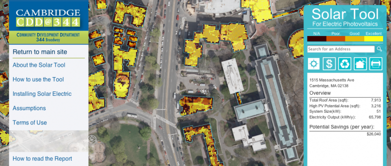
Screencap of the Cambridge Solar Tool
After the Like-A-Hug debacle, the keen minds at MIT are back to fostering ideas that may actually help mankind. In a joint project between MIT’s Sustainable Design Lab and Boston design company Modern Development Studio, researchers have developed a new mapping service that can accurately predict the solar power potential of almost any city rooftop.
Using a sophisticated algorithm that examines solar radiation and Light Detection and Ranging data, the MIT team can determine a rating for each and every square metre of city rooftop. The rating ranges from poor to excellent based on how suited a particular metre of rooftop is for a solar panel. Beyond mapping rooftops, however, the service also provides additional useful information – for instance, clicking on any house on the map will tell vistors to the site how much money is saved using solar panels, how long it will take for the panels to pay for a return on investment, as well as other helpful information.
Currently, the team has only mapped out the roofs of nearby Cambridge, Massachusetts, but, with additional work, the team’s platform could map rooftops throughout the world. [Atlantic Cities]
____
Igor Bonifacic is a writer working for the Toronto Standard. You can follow him on twitter at @igorbonifacic.
For more, follow us on Twitter @TorontoStandard and subscribe to our newsletter.